Are you writing the National Examination Council in also know as NECO, if yes, you need the NECO Geography Past Questions and Answer for Paper II (Essay), Paper III (Objective) and Paper I (Practical).
we at stcharlesedu.com has compiled a good number of NECO Geography past question Paper.
Our research has confirm that candidate that who uses NECO Geography Past Questions to prepare for National Examination Council is ten times better than those who do not.
Table of Contents
Download NECO Geography Past Questions pdf
Click to Download your free NECO Past Question on Geography Paper 3 and 1 (Objective & Practical).
Download Now
How to Buy NECO Past Questions on Geography.
To get the complete copy of the Past Questions, call or whatsapp me on 08051311885
Cost or Price of NECO Geography Past Question N500.
Like our Facebook Page to Download Free NECO Past Questions
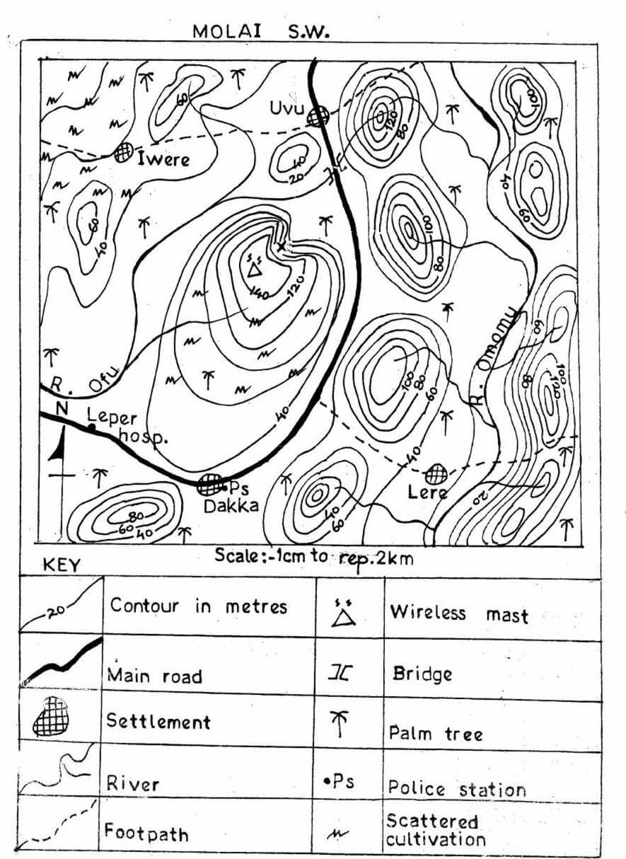
NECO Geography Map Reading.
Map of MOLAI S.W
Scale: 1cm to Rep 2km
NECO Geography Objective Questions for 2019
PAPER III
Answer all questions.
Each question is followed by five options lettered A – E. Choose the correct option for each question and shade in pencil on your answer sheet, die answer space that bears the same letter as the option you have chosen. Give only one answer to each question and erase completely any answer you wish to change.
Do all rough work on this question paper.
An example is given below.
Which of these countries does not share border with Nigeria?
A. Benin
B. Cameroon
C. Chad
D. Niger
E. Togo
The correct option is “Togo” which is lettered E. Therefore answer space E would be shaded.
[A] [B] [C] [D] [E]
Use the map of MOLAI S.W to answer questions 1 -10.
1. The scale of the map in Representative Fraction is
A. 1:50,000.
B. 1:100,000.
C. 1:150,000.
D. 1:200,000.
E. 1:250,000.
2. What is the approximate distance in Km, along the footpath, from Iwere to Uvu?
A. 5
B. 6
C. 7
D. 9
E. 10
3. The contour interval of the map in meters is
A. 20.
B. 30.
C. 40.
D. 50.
E. 100.
4 The wireless mast on the map is located on an altitude of________
metres.
A. 40
B. 100
C. 120
D. 140
E. 160
5. Which of the following pairs of settlements is intervisible?
A. Dakka and Lere
B. Dakka and Uvu
C. Iwere and Lere
D. Iwere and Uvu
E. Lere and Uvu
6. The drainage pattern of River Omomu can be described as
A. annular.
B. centripetal.
C. dendritic.
D. radial.
E. trellis.
7. The feature marked ‘X’ is a/an
A. cliff.
B. escarpment.
C. hill.
D. knoll.
E. valley.
8. The inhabitants of Iwere are most likely to be engaged in
A. farming.
B. fishing.
C. lumbering.
D. mining.
E. quarrying.
9. The approximate bearing of Dakka settlement from the Leper Hospital is
A. 65°.
B. 115°.
C. 120°.
D. 276°.
E. 320°.
10. What is the direction of flow of River Ofu?
A. East
B. North
C. North-West
D. North-East
E. South-West
11. The planet that rotates in a clockwise direction is the
A. Earth.
B. Jupiter.
C. Pluto.
D. Uranus.
E. Venus.
12. Which of the following is not an effect of earth rotation?
A. Day and night
B. Deflection of winds and ocean currents
C. Seasonal changes
D. Dawn and twilight
E. Daily rising and falling of
What others are downloading
Geography NECO Practical Past Questions for 2019
PAPER I
ELEMENTS OF PRACTICAL AND PHYSICAL GEOGRAPHY
Answer questions one and any other three.
1 (a) Draw an outline of Kwali S.E to a scale of 1:150,000.
On your outline, insert the following:
(i) River Gurara and its direction of flow with an arrow.
(ii) The minor road.
(iii) Settlement of Pandaji.
(b) With evidence from the map, describe three landuse patterns of Kwali S.E.
2.With relevant diagrams, explain the following terms:
(a)
(i) Solstice
(ii) Equinox
(iii) International date line
(b) Highlight two differences between lines of latitude and longitude.
3(a) Describe the mode of formation of metamorphic rocks.
(b) Explain three features of metamorphic rocks.
(c) Outline four economic importance of metamorphic rocks.
4. Describe how the following factors affect climate:
(i) Latitude.
(ii) Vegetation.
(iii) Distance from the sea.
(iv) Prevailing winds.
5(a) What is Weathering?
(b) Discuss three factors that affect weathering.
6(a) Explain four processes of wave erosion.
(b) Mention four land forms produced by wave erosion.